Friday, January 23, 2015

Kachina Natural Bridge, January

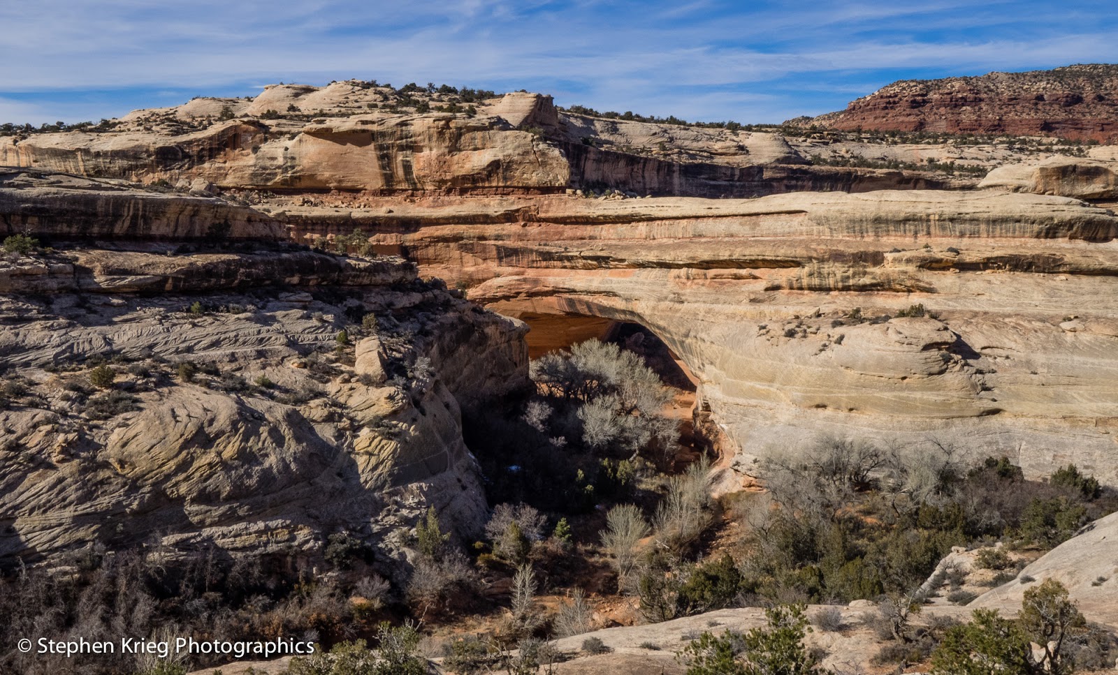
[Kachina Bridge, from the west buttress.]
Natural Bridges National Monument in southeast Utah is the only place in the world with three massive natural stone bridges in such close proximity to each other. 

I decided to revisit the youngest of the three, Kachina Bridge. The trail was free of ice from the past two storms, because there it faces almost west, and so it gets afternoon sun in the low light of winter. 

Down the stone trail, across slickrock and down some stone steps cut into the bedrock, or built upon it. One short ladder section, bolted to the cliff and polished smooth by the hands and boots of many hikers. 

[Kachina Bridge, west face, halfway down the trail.] 

Down to the canyon bottom. The stones and soft sand of the stream bed. Down underneath the belly of the massive stone beast arching above. 

Nice afternoon light. 

I climbed the sand embankment at the west buttress. Photographed a pile of massive boulders created by the most recent shedding of rock from the bridge above, in the 1990's. 

Then photographed some ancient (700 years ago, plus) artwork on the stone buttresses. The Hopi say they can trace these symbols to their ancestral clans, before they migrated to the Hopi mesas down in northeast Arizona. 

Incredible to ponder.

[Bighorn sheep petroglyph and yellow hands pictographs, Kachina Bridge.] 

Photo location: Natural Bridges National Monument, San Juan County, southeast Utah.

© 2015 Stephen J. Krieg


Friday, January 16, 2015

Snowy Peaks, Red Rock Canyons

[Comb Ridge, San Juan County, Utah] 
A local friend calls Highway 95 west from Blanding, Utah "the road to the good stuff". And she should know, having combed this region for about 30 years. 

So I was again driving Hwy. 95 west, savoring the sights as usual. Up and through the massive cut in the red sandstone at the crest of Comb Ridge. Then down the west side, crossing Comb Wash. And up onto Cedar Mesa, the million-acre wild land with all the rugged canyons cut into its sides. Where everybody comes to hike down in to see the ancient Anasazi / Ancestral Puebloan cliff dwelling ruins that were last inhabited about 700 years ago. Great stuff. Part of my friend's "good stuff". 

Pulling over at a favorite viewpoint where I could see north from the lip of Cedar Mesa, I enjoyed the view toward Comb Ridge and the distant Abajo, or Blue, Mountains west of Blanding and Monticello. 
a
[Abajo Mountains through the clouds, from Cedar Mesa] 
This sums up a lot of what I appreciate about San Juan County: red rock canyons and snow capped mountains. Geology, archaeology, ecological diversity, and plenty of it.

© 2015 Stephen J. Krieg

Sunday, January 11, 2015

Snowscapes in Slickrock Country

[Butler Wash area in snow, San Juan County.] 
A lovely mid winter storm in southeast Utah. Canyon Country, Four Corners Country. Perfect snow, and I was in the mood for roaming outdoors again.

From Blanding west on Highway 95. Such a wonderfully lonesome road. Unless you consider the seeming suicidal deer, which can instantly decide that somehow the other side of the road must be the safer side. 

On this morning, though, the snowstorm had the deer bedded down in the trees, in the draws, out of harm's way. So the highway was mine.

I had plenty of time. Thus a diversion: stop and hike the short (half mile) trail to the viewpoint of Butler Wash Ruins. 
[Snowy bench, Butler Wash] 
"Ruins," as in the remains of ancient pueblos, tucked under a massive sandstone cliff. I had visited there before, even hiked down into the Wash and up to the ruins themselves. But today I would content myself with confining myself to the trail to the overlook. It should be beautiful, and slippery enough without being even more adventuresome.
[700-year-old (or so) pueblo ruins.] 
I was the first one through the virgin snow that day. It was still so overcast, and the snow so white, that it was hard to discern the lay of the trail. So I stumbled and slid a bit, taking care not to fall. My goal was to make it to the viewpoint without putting my traction aids on my boots, just to see whether I could. 

I decided I couldn't. Or at least shouldn't. The experiment was complete, so I stretched them over my soles and enjoyed a much more confident trek.
[Pull-on traction devices, huge difference.]
At the ruins overlook, I made my photos and video of the wide mouthed alcoves in the cliff across the way. Then I started back toward the trailhead. The view to the south caught my eye, so I strayed off trail across the sandstone slickrock. The tiny intermittent stream was flowing down through the snow. Beautiful, sensual patterns in the perfect snow.
[Small pools in the slick rock.] 
[Sideways slickrock stream.]  
 
[Snowflakes on ice veneer, on pool.] 

[Prickly pear cactus in the snow.] 

Photo location: San Juan County, southeast Utah.

Prints and photo products are available on my Fine Art America sales website:
http://stephen-krieg.pixels.com/


© 2015 Stephen J. Krieg 

Tuesday, January 6, 2015

The Clouds Part

Highway 95, west of Natural Bridges, Utah.
Utah Highway 95, down along White Canyon. No cell service, no problem. Because I'd rather be using my camera, anyway.

An inversion still had the cloud cover down low. But not all the way to the river. Sweet. I could play both sides of it just by driving along.

Fresh snow, fog, blue skies, red rock cliffs. A highway so lonesome you only see a few cars in an hour.

Photo location: San Juan County, southeast Utah.


Monday, January 5, 2015

Down White Canyon

Utah Highway 14, east of Hanksville, Utah.
 The highway goes on forever. Doesn't it?

Shouldn't it?