Sunday, November 5, 2017

Mesa Verde: Sunset Glow At Square Tower House

Square Tower House Ancestral Puebloan ruin, Mesa Verde National Park, Colorado.
Square Tower House alcove just before sunset, Mesa Verde National Park, Colorado.
November has arrived. Up in Mesa Verde National Park at the park's south end, (7,000 feet elevation), I spent an evening seeing how the much lower angle of the autumn sun was working the sunset light on the cliff dwellings.

On the beginning of the Mesa Top Loop road, I soon was able to see how Navajo Canyon was lit up by the low angle of the late autumn sun. Square Tower House, I thought, was going to look really good.

And it did. But it was still a half hour or so until sunset. So I drove on to see how the light was playing on some of the other Ancestral Puebloan cliff dwelling remains along the drive.

Oak Tree House alcove, early November afternoon sunlight.
Cliff Palace, as the pre-sunset shadows come up the alcove wall well before sunset.
Nice, but I was really interested in seeing how Square Tower House would look at sunset.

I swung back around the loop and parked and returned to the overlook. I was the only one there. I kept glancing at the sun, so low above the mesa top to the south. The lower the angle of the sun, the warmer the light would be. Each few minutes mattered, the difference noticeable.

As the shadows came up the alcove wall, the warm sunlight glow intensified. It seems to do this better at Square Tower House than at Cliff Palace because the adjacent canyon (Navajo Canyon) is wider, allowing the sun to be even lower before it finally disappears below the far canyon rim.

Square Tower House in sunset glow.
Photo location: Mesa Verde National Park, southwest Colorado.

See more of my photography at www.NaturalMoment.com

© Copyright Stephen J. Krieg

Thursday, October 12, 2017

High Peaks Sunrise and Valley Fall Colors

Moon setting at dawn, Rico, Colorado, October 7.
October 7, and I was driving up the Dolores River valley in southwest Colorado for another day of experiencing the fall colors. It was still dark as I left Cortez, and cruised through the town of Dolores.

Approaching Rico, dawn was occurring. When it got light enough to take decent landscape photos, I made some compositions with the just past Full moon getting ready to set behind the San Juan Mountains with their aspen forests fall colors.

Dawn at the beaver ponds on the edge of Rico.
At the edge of town I turned off on a gravel road that I knew bordered some old beaver ponds. A nice wide open view of the mountains, and a glassy reflection provided by the water's surface.

Sunrise on the high peak, above and below.
I was about to continue on my way when the sunrise lit up a high peak above timberline with an orange glow. And reflected on the pond's surface.

See more of my photography on my website: www.NaturalMoment.com.

Photo location: Rico, southwest Colorado.

© Copyright 2017 Stephen J. Krieg

Tuesday, October 3, 2017

Rico, Colorado Fall Colors

Fall colors from Rico Community Church on an overcast morning, September 30, 2017.
As I track the progression of the fall colors in the San Juan Mountains of southwest Colorado, I return again and again to the tiny community of Rico. Once the county seat when it was a mining boom town, it's now part tourist destination, part bedroom community for people working in Telluride.

At about 8,800 feet in elevation it's a good bellweather of what's going on in the high country, ringed by high mountain peaks.

Fall colors on a sunny afternoon, October 7, 2017.
I returned a week later, on a perfect early October day. Warm, no haze to speak of, and no wind.

Photo location: Rico, Colorado.

See more of my photography on my website: www.NaturalMoment.com.

© Copyright 2017 Stephen J. Krieg

Sunday, September 24, 2017

Aspen Colors in First Snow


Orange, yellow and green aspen tree foliage in the first snow of the high country.

Photo location: San Juan National Forest, Colorado.

© Copyright Stephen J. Krieg

Saturday, September 16, 2017

First Fall Weather at Mesa Verde


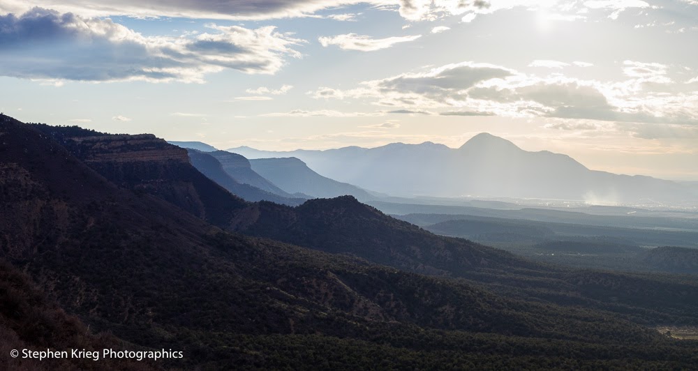
Rain curtain from the Navajo Canyon overlook, Mesa Verde.

Mid September, and I'm enjoying the first fall weather of the season, which looks like it's going to continue. Goodbye summertime heat at last?

I drove the Mesa Top Loop road first, just after the first hard rain in weeks had moved on.

Oak Tree House cliff dwelling ruin, Mesa Verde National Park, Colorado.
Oak Tree House cliff dwelling, after the rain.
The overall lighting was poor, so I concentrated on eliminating the sky in most of my shots. I was interested in how the wet Cliff Dwelling Sandstone layer was showing off its dark streaks of desert varnish even more prominently.

Fire House cliff dwelling ruin, Mesa Verde National Park, Colorado
Fire House cliff dwelling.
At Sun Temple's "Camera Point" I got a nicely saturated panorama of Cliff Palace.

Cliff Palace cliff dwelling ruin, Mesa Verde National Park, Colorado.
Cliff Palace from across the canyon at Camera Point.
Inside the Cliff Palace alcove, the Ranger-led tour's visitors were enjoying being nice and dry.

Cliff Palace cliff dwelling ruin, Mesa Verde National Park, Colorado.
Tour group at Cliff Palace.
The Mesa Top Loop completed, it was time to continue outbound from the southwest end of the Park.

Wild turkeys, Mesa Verde National Park, Colorado.
Young wild turkey drinking from the rumble strip gouges in the road.

On the way to Far View, where the park's lodge is located, I came across the same hen (female) and youngster wild turkey pair that I'd seen on the way in that morning.

Being in a National Park where no hunting is allowed, they were quite casual. I watched them drink from the "rumble strip" depressions in the road's centerline, as I had seen other birds do. A convenient way for a quick drink of cool, clear water after the storm.

Mother and youngster wild turkeys.
Since there was only one poult (hatchling) with the mother hen on both sightings, I assumed that the rest of the young ones had been killed, probably picked off one by one by predators. Which is why each hen hatches a clutch of eggs, not just one.

Clearing rain storm, Mesa Verde National Park, Colorado.
Storm to the south, from Park Point.
At Park Point I made a panorama of the slowly clearing skies and the rain storm still underway down toward Shiprock, New Mexico. Then I shifted my view to the north for a nice wet view toward the Knife Edge cliff formation, with the La Plata Mountains in the distance.

Mesa Verde's North Rim and clearing storm, Mesa Verde National Park, Colorado.
Looking north toward the Knife Edge, from Park Point.
While at Park Point I made some shots of early fall colors in some Gambel Oak leaves. With the chilly nights in the forecast things should be changing quickly.

Gambel Oak - Quercus gambellii - early fall colors, Mesa Verde National Park, Colorado.
A few Gambel Oak (Quercus gambellii) early fall colors.
Serviceberry (Amelanchier alnifolia) early fall colors at Mesa Verde National Park
Serviceberry (Amelanchier alnifolia) early fall colors.
As a closing touch, I photographed a lovely thunderhead cloud before continuing down from the North Rim and out of the park.

Thunderhead cloud, Mesa Verde National Park, Colorado
Thunderhead cloud from Park Point.

Photo location: Mesa Verde National Park, southwest Colorado.

© Copyright 2017 Stephen J. Krieg

Friday, August 18, 2017

Days So Much Shorter

Pinon Pine snag at Montezuma Valley Overlook.
It's August now. Late summer. It's been a spectacular one, too. Rain showers in the afternoon, keeping the land green. Minimizing the wildfire danger.

At this time of the year, the days (length of daylight) are getting shorter by about two minutes a day. Meaning an hour a month. As we slide out of the heat of summer into the glorious coolness of autumn, starting in September. It won't be long.
 
Photo location: Mesa Verde National Park, southwest Colorado.

See more of my photography at www.NaturalMoment.com

© Copyright 2017 Stephen J. Krieg

Saturday, July 29, 2017

Mesa Verde Summertime View

Navajo Canyon, Mesa Verde.
It's mid summer. Here comes late summer right around the corner. I try to enjoy all the seasons.

People are saying: "It's almost August! Where is the summer going?" It's going day by day, of course.

Soon it will be fall, my favorite time of year. But not yet. Here on the Colorado Plateau, it's monsoon thunderstorm season, the beautiful time when southern moisture collides with hot high country temperatures and boils over in the skies. When all manner of blues and whites and grays make for a mesmerizing palette above.

Navajo Canyon cliffs.
Up on Mesa Verde, I continue to watch things progress through the summer. The vegetation growing until it's once again time to settle in for the coming cold season.

Once again I look down upon Cliff Palace, the largest cliff dwelling in North America.

Cliff Place at Mesa Verde.
Meanwhile, in the parking lot, the Rabbitbrush are beginning to bloom. A butterfly is sufficiently distracted as to allow me to take some photos of it from a few feet away.

Butterfly on Rabbitbrush blooms, Cliff Palace parking lot.
Photo location: Mesa Verde National Park, southwest Colorado.

© Copyright 2017 Stephen J. Krieg

Tuesday, July 18, 2017

High Country Summer

Colorado Hwy. 145 near Lizard Head Pass
It was the end of June, and I had not been back up into the southwest Colorado high country in over a month.

Up the Dolores river valley from the quaint and historic river town of Dolores on Highway 145. Up past the hamlet of Stoner, and Rico, my favorite mountain town. But I could not stop there, as I had a long way to go.

Lizard Head Pass, late June.
The aspen forests high above were in full greenery, as were the alpine tundra fields above them, even if only slightly less so. Shades of green against blue mountains, and skies.

Lizard Head Peak, from the Pass.
And before long I was back up at Lizard Head Pass. The snowfields above timberline had been melting rapidly. The uppermost reaches of the streams were losing their turbidity (muddy-ness) after the high water mark of spring runoff of the snowfields in the surrounding mountains.

I settled into a campsite. A "dispersed campsite", meaning it was just a spot on the National Forest. No facilities, just me and nature. There was a well used fire ring there, but I had no desire for a campfire.

I began to look around at the wildflowers.


Then some deer walked almost right through my camp. Alert but relatively unconcerned, they know when it's hunting season and when it's not.


See more of my photography at www.NaturalMoment.com.

© Copyright 2017 Stephen J. Krieg

Tuesday, July 11, 2017

Starry, Really Starry Night at 10,000 Feet

Milky Way and infinite friends, from Lizard Head Pass.
Summertime, and the living's easy. Right? Especially up in the Rocky Mountains of southwest Colorado.

I was back up at Lizard Head Pass, and had found an excellent campsite on the National Forest to settle into. A day off, plenty of provisions, nowhere else to be but to be relaxed and savoring the experience.

Sunset turned to dusk, and to sleep. Good night. But something was bugging me: being back underneath a clear dark sky view of the Milky Way again.

I'm no night owl. I like going to bed early and getting up early. But I wanted to once again try my hand at some night sky photography.

So at one point I peered out the window and upward just to confirm that the Milky Way was still up there. Got that done. Then I dozed off. And woke up dreaming that I was photographing it! Oh, I thought, I'd better just get up and actually do it. Otherwise it will be fits and starts of dreams all night.

So I sleepily set up the tripod and camera and had what could best be described as a good effort. Which, in post production back at home (fully awake) turned out to be not bad. Progress from my earlier attempts.

To the north, I framed the spruce and fir trees in silhouette against the sky. After all, who needs another great shot of the night sky without an Earthly reference?

Southern sky, the Galactic Center.
Then, to the south. The Galactic Center was in view. Such shots are often called fake, because they look like star clouds.

The reality is that the camera sensor records more than our eyes can see at the time. Also, city people have no night vision because of all the light pollution. Come up here to 10,000 feet and look up at the night sky. Without turning on any white lights. You could see so much more than you imagined.

At any rate, these are my best depictions of what I experienced that starry, starry night.

Photo location: Lizard Head Pass, San Juan National Forest, Colorado.

See more of my photography at www.NaturalMoment.com.

© Copyright 2017 Stephen J. Krieg

Saturday, June 10, 2017

Moonrise, Moonset, and Sleeping Ute Mountain

Totten Reservoir, Mesa Verde, and Sleeping Ute Mountain.
It was Full Moon time, that time of the month to once again try for great landscape photos featuring the moonrise.

In June, sunset occurs late, just after 8:30 PM, which is also about the time that the Full Moon rises in the east. So I had some time to kill.

I drove to Totten Reservoir just east of Cortez, in part because the late afternoon haze was making Sleeping Ute Mountain stand out on the southwestern skyline. Mostly clear blue skies, a nice breeze, the warming light of the lowering sun.

Sleeping Ute Mountain from Totten Reservoir.
Sleeping Ute Mountain is a small but prominent mountain range in southwest Colorado. It lies wholly within the Ute Mountain Indian Reservation, meaning it's off limits to non-tribal members except by certain advance tours with a guide.

Why is it called Sleeping Ute? To the right is the warrior's head, with his headdress flowing out. (He seems to have no nose, who knows?). His arms are folded across his chest, forming Ute Peak on the map. To the far left his knees are visible, and even the tips of his toes. It is said that Sleeping Ute will awaken when his tribe needs him, so take heed!

But to the east is the North Rim of Mesa Verde, the dazzling cliffs that form the backdrop to the town of Cortez. It was there that the moonrise would appear over. Earlier in the afternoon I had alerted some visitors going into the park to watch for it. City dwellers are unaware of such things, and they delight in being given such tips to enjoy with their families.

Moonrise over the North Rim of Mesa Verde, from Cortez.
The sun went down and the shadows of Mesa Verde as seen from my vantage point near the southern edge of Cortez deepened. It was getting too dark for my favored kind of moonrise landscape photos.

Full Moon after it got too dark for good landscape shots.

But about 9 PM the Full Moon (actually a bit past 100% illumination, but who's counting) started to peek over the rim of the Mesa. Shots made a few minutes later were too wildly contrasty to satisfy me. Who needs yet another shot of the gorgeous moon in a black sky? Mesmerizing as it is.

In the morning, though, the rest of the Full Moon event is moonset at dawn. So I was back out at the lake for more. I had slept in, and had to scramble out there to see what was available. I was not disappointed.

Moonset at dawn, Totten Lake.

Photo Location: Totten Reservoir State Wildlife Area, Montezuma County, southwest Colorado.

See more of my photography at www.NaturalMoment.com.

© Copyright 2017 Stephen J. Krieg


Friday, June 2, 2017

Mesa Verde Wildflowers: Fendlerbush

Fendlerbush blossoms, Mesa Verde National Park, Colorado
The first day of June in Mesa Verde National Park. I stopped at the Far View pueblo sites for an early evening walk. Being on the mesa top, it's an easy walk, and it was a beautiful late afternoon.

Before long I came upon more Fendlerbush (Fendlera falcata (F. rupicola), which have been blooming for a while now. Still they are not done, at least not certain shrubs in the park. With the late afternoon light illuminating them from behind, they glowed even more. The deep shadows behind only served to make them stand out even more.

Their flower buds are pink, but as they open they turn a very pure white. The four petals make them an easy identify up here. 

Photo location: Mesa Verde National Park, southwest Colorado. See more of my photography at www.NaturalMoment.com.

© Copyright 2017 Stephen J. Krieg

Friday, May 12, 2017

Mesa Verde from Park Point

Looking south from Park Point, Mesa Verde National Park, Colorado.
Early May, and the spring season is well along. Not far from the Memorial Day weekend start to the real crush of visitors. A great time to explore the park before it gets hot and crowded.

I had been working at the Museum and was driving home. The past few days had been wet and cold. The warm weather residents that were visiting were miserable and complaining a bit. Hey, springtime in the Rockies....

But the cold front passed, and cumulus clouds were accenting the blue sky once again. As I drove north from the Museum on Chapin Mesa, I stopped at Park Point, highest knob of landscape within the park. It has 360 degree views all around.

 Photo location: Mesa Verde National Park, southwest Colorado.

© Copyright 2017 Stephen J. Krieg

Tuesday, May 9, 2017

The Great Sage Plain Greens Up

Winter wheat fields and Abajo Mountains, Dove Creek, Colorado
Going home, early May. Dove Creek, southwest Colorado.

Actually I had come up from the lower Dolores River at Slick Rock, enjoying the swollen river and the boaters floating down to their take-out landing.

Then I drove up over the landscape, over high mesas, and came back out to Highway 491. What a view. The fields of winter wheat so green in the cold wet springtime soil. The Abajo Mountains in the distance, in Utah 20 miles west. The wet skies dancing about, teasing a bit more rain.

Photo location: Dove Creek, Colorado.

See more of my photography at www.NaturalMoment.com.

© Copyright 2017 Stephen J. Krieg

Tuesday, May 2, 2017

La Sal Mountains Springtime Sunset

La Sal Mountains at sunset from near the Bears Ears National Monument boundary, San Juan County.
Late April in southeast Utah and the Four Corners country, and the weather was moody. I like the variety that it provides.

Driving west out of Monticello toward the Abajo Mountains, the road veers northward toward Utah 211, the highway into the Needles District of Canyonlands National Park. But before you get anywhere near that portion of the park, you cross the invisible boundary (since it's so new) of part of the eastern boundary of Bears Ears National Monument.

That evening, my eye was not on going into the Needles, but on staying high to watch how the sunset light would play out onto the La Sal Mountains to the northeast, near Moab.

As the sun slid below the western horizon, the low angle of its light lit up the still snowy peaks of the La Sals. Warmer, then a bit pink, too.

La Sal Mountains peaks at sunset color.
Zooming in with a longer lens, I made a series of overlapping shots from which to make a super high resolution panoramic image in Adobe Lightroom.

Soon the colors had faded, and it was time to drive home in the twilight. 

See more of my photography at www.NaturalMoment.com.

© Copyright 2017 Stephen J. Krieg

Saturday, April 15, 2017

Moonset Over the Abajos

Moonset at sunrise, near Monticello, Utah.
I had been intending to take off in the other direction, until I exited my front door and saw the just past full moon setting over the Abajo Mountains. Hmm. Did I have time to do something about it? I did.

So I drove out to Loyds Lake on the edge of town. A favored vantage point. I quickly parked, grabbed my camera bag and tripod, and all but trotted down the gravel path. Because I could see there was no time to waste.

Loyds Lake at sunrise, with the moon setting over the Abajos.
 Whenever the moon is rising above the horizon, or setting in the other direction, it's amazing to see how quickly our Earth rotates compared to how we think of it (if at all) while we are caught up in the day. The frame of reference that the horizon brings is telling.

The moon was creeping down toward the still snowy Abajo Mountains west of town. The sun was rising as well, giving the landscape a warming glow while the moon was cool and blue. After all, it was still way out there in space.

Photo location: Monticello, southeast Utah.

© Copyright 2017 Stephen J. Krieg

Thursday, April 13, 2017

Mesa Verde: North Rim April Evening

Mesa Verde's North Rim escarpment from the Geologic Overlook.
"Light forms the image" wrote legendary photographer Edward Weston (1886-1958). Meaning the quality of the light at the time. The type of light, and how it played off of the surfaces in the scene.

Our world is lit by our Sun. But it is our atmosphere that filters that sunlight in many ways. Clouds have much to do with it, by their absence or presence, and by what type of cloud it is.

View north across the Montezuma Valley, with the Knife Edge lit up.
On a recent April evening as I drove along the North Rim of Mesa Verde, I had the pleasure of watching the afternoon sunlight and clouds play across the scenery.

Hazy evening silhouettes from the North Rim of Mesa Verde, with Sleeping Ute Mountain in the distance.
It was hazy down in the Montezuma Valley, making the light separate ridges and peaks from near to far.
Dead tree like a statue at the Montezuma Valley Overlook, Mesa Verde.
Photo location: Mesa Verde National Park, southwest Colorado.

See more of my photography at www.NaturalMoment.com.

© Copyright 2017 Stephen J. Krieg