Showing posts with label Arizona. Show all posts

Saturday, May 23, 2015

Welcome To Utah...

"Welcome to Utah" sign and tourists, near Monument Valley.

...Land of illicit stickers on state highway signs? 

There was a busload of Asian tourists at the state line, at Monument Valley. World famous Monument Valley. Having driven past this sign oh so many times, I finally noticed all the stickers on it. I guess I was always too focused on the scenery behind it. I would never even consider slapping some sticker on a state highway sign. 

Anyway, I loved watching the visitors having so much fun, taking pictures of each other. They get to visit, I get to live here. 

Photo location: Arizona/Utah state line at Monument Valley, Arizona. 

© 2015 Stephen J. Krieg

Sunday, September 21, 2014

Aspen Colors Closeup, Kaibab Plateau

  
[Photo: Aspen leaves, Kaibab National Forest, Arizona].


Autumn continues its slow but gradual progression up on the Kaibab Plateau on the northern Arizona Strip. Warm, shortening days along with cool nights still free of frost or an early snow are doing the job. Those conditions tell the aspen trees that there is no hurry to drop leaves. A gradual lessening of the green chlorophyll in their leaves reveals the other colors, especially yellow and gold, sometimes orange and red.

I was slowly cruising through the Kaibab National Forest between Jacob Lake and the North Rim of Grand Canyon, looking for the earliest colors. In the morning light I was able to get close to some lower branches with outstanding colors. The Still green foliage of the other trees behind it served as a rich background to contrast with, along with the clear blue sky.

Autumn gold, blue skies, warm sunlight, chilly nights. The best time of year.

Photo location: Kaibab National Forest, North Kaibab District, near DeMotte Park, Arizona. 

Sunday, August 17, 2014

Kaibab Forest Sunset

Sunset, Warm Fire burn, Kaibab National Forest, Arizona
August on the Kaibab Plateau, the "mountain lying down" to the Paiute Indians. The high (7,000-9,000) gently curved mountain with no peaks, raised up from the Marble Platform down below by the Earth's ever flexing forces.

Near the edge of the now eight year old burn left by 1996's Warm Fire (an ironic name for such a massive, hot fire, almost 60,000 acres) I took advantage of the opening in the forest to admire some sunset cloud colors. The day had been one of summer monsoon thundershower activity, but all around me rather than on me. The leftover thunderhead and cumulus clouds reflected the setting sun, and the Ponderosa pine trees provided some nice silhouette shapes.

Photo location: North Kaibab Ranger District, Kaibab National Forest, between Jacob Lake and North Rim of Grand Canyon, Coconino County, Arizona. 

Wednesday, July 16, 2014

Kaibab Plateau: Sunset Rain Colors, Rainbow Rim

[Photo: Sunset rain colors, Rainbow Rim, northern Arizona.]
A summer evening on the Rainbow Rim in northern Arizona. July: the summer monsoon season has begun. Moisture from Baja California flows north into Arizona, and the clouds build quickly in the mornings. Most mornings. 

Thunder in the afternoon. Lightning around, so keep a wary eye out. Make sure you're not too exposed if it gets within about ten miles of you. If you see lightning in the distance but can't hear the associated thunder, it's too far away to be of concern.

Rain blesses the high desert, and the high lush forests of the Kaibab Plateau. At sunset time, a gap in the clouds on the western horizon arrives right on time. The rain and clouds provide the reflector screen, the veil, for the setting sun, warming the colors to yellow, pink, purple against the blue light in the shadows. 

The Rainbow Rim sits on the edge of two giant chunks of federal land: the North Rim of Grand Canyon National Park, and the North Kaibab Ranger District of the Kaibab National Forest. On the cusp. Looking down into Grand Canyon north of the Colorado River. 

Photo location: Rainbow Rim, Kaibab National Forest and Grand Canyon National Park, Arizona. Copyright © 2014 Stephen J. Krieg.

Sunday, May 11, 2014

Vermilion Cliffs Golden Sunset Shower

Sunset through rain shower, Vermilion Cliffs, Arizona
An April shower on the Marble Platform on the Arizona Strip between Grand Canyon and the Utah state line. Sunset providing the golden light through the rain. The Vermilion Cliffs towering in profile. 

What a day in April 2011 that was. 

Monday, April 14, 2014

April Full Moonrise, Central Arizona Highlands

Moonrise over Bradshaw Mountains, Prescott, Arizona
Moonrise this evening in Arizona was the time to make landscape shots with the Full Moon included in the frame, because the moon rose early enough to be in the scene while the landscape was still light enough for some detail.

The savvy landscape/nature photographer was not fooled by the calendar, which shows the Full Moon as being tomorrow. But that's because it will officially reach 100% illumination just after midnight Pacific Time (and Arizona Standard Time). 

So effectively this evening was the rise of the Full Moon. Here is what it looked like from the southeast edge of Prescott, Arizona, with the Bradshaw Mountains on the horizon. The "starburst" effect was from the small lens aperture, in this case f/18.

Monday, April 7, 2014

Granite Mountain Reflection, Prescott National Forest


Granite Mountain reflection on Granite Basin Lake

Morning light. Mountain light. Clear air after a spring snow storm. Synergy.

I drove west out of Prescott up into Granite Basin Recreation Area on the Prescott National Forest. It can be a very busy area on the weekend, being that close to town, but this wasn't the weekend. Ha.

A perfect early April morning in the Central Arizona Highlands. A mountain lake, Granite Lake, slowly undulating the mirror image of Granite Mountain and the clear blue Arizona sky.


Granite Mountain and Granite Basin Lake
Photo location: Granite Basin Recreation Area, Prescott National Forest, just west of Prescott, Arizona.

© Stephen J. Krieg | www.NaturalMoment.com

Saturday, March 29, 2014

Local Tourist: Downtown Prescott, Arizona

A beautiful late March day in mile high Prescott, Arizona. 

Gurley Street, looking west toward Thumb Butte
I had most of the day to wander as I felt like, having dropped my vehicle off at a local auto repair shop for some good upgrade work to engine and brakes. I had intended to spend most of my time in the Sharlot Hall Museum, but to my delight some gorgeous, ever changing cumulus clouds had shown up. And the air was crisp and clear. A photographer's playground. Time to play "local tourist", exploring like a rubbernecking newcomer but with the familiarity of a resident. The best of both worlds.

Gurley Street, looking east from Courthouse Plaza ("the Square")

I like downtown Prescott because it has a number of old, historic buildings that are inhabited by local businesses. No chain stores or restaurants here. With the beautiful light and plenty of time on my hands I decided to wander the streets as a tourist would. I had only lived in the area a year, and so it would be a chance to visit some of the shops that I hadn't yet, as well as re-visit those I knew already, to see what had changed.


The beautiful Hassayampa Inn on Gurley Street
The downtown core is centered around the Yavapai County Courthouse, a stately granite building surrounded by the lawns and sidewalks and American elm trees of its plaza, universally called "Courthouse Square" or "the Square" by the locals even though the city maps and signs insist it's officially Courthouse Plaza. 

Whiskey Row (right), Montezuma Street across from the Courthouse Plaza (left).

On the north side of the Square is Gurley Street, which is Prescott's Main Street. Gurley Street comes down the hill from the east at the beautiful red-brick Hassayampa Inn and the Elks Theatre, and points west toward Thumb Butte, the iconic upthrust on the Prescott National Forest just west of downtown.

Gun lovers' signs for sale.
Prescott revels in its "Old West" cowboy, pioneer, and mining history. Also in being a mile high in elevation, making its climate about as perfect as you can get. With the iconic Arizona blue skies, low humidity, and moderate temperatures, Prescott is off the beaten path (Interstate 17) while being not that far from it, either. 

Alongside Courthouse Plaza to the south is Whiskey Row, that block of Montezuma Street with a very colorful (i.e., wild) past and is still the epicenter of downtown's night life. With a number of bars, art galleries, restaurants, and upscale shops, it's a great place to browse and spend an hour or three. And that's during the daylight hours! Wyatt Earp and Doc Holliday are long gone from the scene, but downtown lives on as a mixture of historic and modern. 

 
Hotel St. Michael ("St. Mike's") building anchors the north corner of Whiskey Row

Mountain Spirit Co-Op art gallery and healing center on Cortez Street
However, Cortez Street just north of Gurley Street rivals Whiskey Row for having at least as many restaurants, and with even more shops. At any rate, all of historic downtown Prescott is within easy walking distance, and is very pedestrian-friendly.

Cortez Street Emporium (and mirror for lovely Arizona sky).

The Cortez Street Emporium makes it plain when it's open...and where the entrance is!

Visual collage of inside and outside, near and far, courtesy of the Cortez Street Emporium's front windows.
 
Along Cortez Street

North Cortez Street, Prescott, Arizona

Murphy's Restaurant, Cortez Street

Wandering "local tourist" photographer...

The former train station is now an upscale professional building.

Historic photo from the Sharlot Hall Museum archives shows the train station in its day.

Local businesses aren't shy about turning their walls into public art.
Streetside art on The Lone Spur Cafe, Gurley Street
Adams Specialty Automotive Repair shop, my beginning and ending point near historic downtown.
Granite Basin Lake and Granite Peak, on the Prescott National Forest a few miles west of downtown. Gotta take the vehicle for a little drive after being worked on!
Prints and photo products are available on my Fine Art America sales website:
http://stephen-krieg.pixels.com/


© Copyright 2014 Stephen J. Krieg


Wednesday, January 15, 2014

January Full Moonrise

Moonrise over Watson Lake and the Granite Dells, north of Prescott, Arizona
Another gorgeous Central Arizona Highlands evening, this time on the evening of the Full Moon.

Several miles north of Prescott along Highway 89 lies Watson Lake, a waterfowl rich reservoir formed by a dam on Granite Creek. Bordering the lake are the weird and beautiful rock formations known as the Granite Dells. To the east (upper right in this photo) lies Glassford Hill, an ancient volcano.

A warm January day (unseasonably warm, but so comfortable), calm winds. Using The Photographer's Ephemeris application, I could find out exactly when and in what compass direction (azimuth) the full moon would rise. This month it rose in the northeast at 70 degrees, which is 20 degrees north of straight East. The information allowed me to pick a spot with an enticing landscape, since tonight the moon would rise after sunset but before full dark.

Finally the moon peeked over Glassford Hill and, as the light faded, reflected off the surface of Watson Lake.

Monday, June 3, 2013

Clouds Make the Sunset

Photo: Sunset beams, Chino Valley, Arizona. [Click on image for larger version]
Sunset time. Always beautiful if there aren't too many clouds obscuring the western horizon. For the scenic photographer, though, no clouds at all makes for a relatively boring sunset. Why? Because the right kind of clouds, in the right location above the setting sun, reflect and intensify the colors. Too many  clouds, or too low on the horizon, cut off the sun's rays. At the other extreme, no clouds at all and it's merely a little yellow ball sinking out of sight. 

As this photo shows, it doesn't take many of the right kind of clouds to dramatically enhance the sunset colors. A few puffy clouds above the horizon and there you have it. The moisture in the sky made the sun's rays stream out into sunset beams, and the clouds acted as reflectors of the warm yellow colors.

Photo Location: Little Chino Valley, Yavapai County, Arizona.

---------------
My YouTube Channel: naturalmoment | my website: NaturalMoment.com

All content © Stephen J. Krieg. Prior permission required for usage.

---------------

Friday, May 24, 2013

May Moonrise, Lonesome Valley

Today was full moon Friday, time for May's Full Moon. It would be "100% illuminated", as the scientists say, at about 9:30 PM. After dark, that is.

So, the time to make moonrise shots was around sunset time, before it got too dark. The moon would rise early enough to make it happen. Who cares, or could tell, that it would only be 99.999% illuminated at that time?

Lonesome Valley basalt butte and Granite Mountain (far horizon).
I was in place at the north end of Lonesome Valley, in the central highlands of Yavapai County, Arizona. The basalt buttes and the distant skyline of Granite Mountain provided a nice sunset light scenic to the southwest. 

Then, my attention was to the southeast, toward Mingus Mountain and the Black Hills, where the moon would appear. 

It was a calm, peaceful late spring evening, and nobody was around. The Earth's shadow made its familiar gradation from blue to pink. Then the moon began edging over the horizon of the mountains. Perfect. 

And it was. I made several exposures from wide angle, which showed the Earth's shadow colors better, to medium telephoto, with the mountains larger within the frame. 

Then it was time to go back to my studio and see how I did. Now you can see, too. 

Sunday, May 12, 2013

High Desert Reading Room


A perfect May afternoon in the Central Arizona Highlands of Yavapai County: not just the trademark Arizona blue sky, but also featuring perfect cumulus clouds for an added, slowly changing treat. 

I pulled over at one my my favorite spots at the north end of Lonesome Valley. Time to kick back, drink some water, eat a snack, watch the afternoon go peacefully by. Savor and savor some more until the sunset hour arrived.

I was reading Ellsworth Kolb's Through the Grand Canyon From Wyoming to Mexico, the first person account of he and his brother Emery's famous river expedition that captured the first motion pictures of running the wild river, way back in 1911-12. Being professional photographers, their equipment was their life, especially on that hazardous trip.

Meanwhile, here I was about a hundred years later, with my jewel of a digital camera to photograph with on a lazy spring Saturday, about 80 miles south of Grand Canyon. I was in such a perfect spot that I actually took some of my photos from the cab of my pickup truck, while reading the book. Not exactly an expedition. Just incredibly satisfying.

Then I got the idea of shooting a panoramic image from inside the truck, using it as the frame to the scenery I was reveling in. Even a clip of video. To document my mobile reading room.

The Kolb brothers would have appreciated it, I'm sure. Get the shot, no matter how hard, or how easy.

Tuesday, April 30, 2013

Lonesome Valley Basalt Buttes


From the town of Chino Valley in the Central Arizona Highlands I drove east on Perkinsville Road for another sojourn into the hills at the north end of Lonesome Valley. 

A dry early spring. Little rain. Some of the high desert shrubs and forbs and wildflowers appearing, but overall the grasses seem to be waiting for some real moisture. Meanwhile, the blonde prairie grasses, dead since last summer, provided the soft straw yellow coverings to the land. 

The basalt lava buttes here have no names, so I have to make up my own. The double hump on the left is called Was A Pair, since the one hump is much more eroded than its twin. Behind them to the right is Nipple Butte, though it doesn't look like its namesake from this viewpoint. 

Photo location: Lonesome Valley, east of Chino Valley and north of Prescott, Yavapai County, Arizona.

Wednesday, April 10, 2013

Spring Snow, Prescott Basin

Photo: Thumb Butte and the Bradshaw Mountains, near Prescott, Arizona

April 9 dawned cloudy but clearing. Snow had fallen after rain, hopefully soaking the ground enough to trigger grasses and wildflowers soon. 

The clouds began to break up at sunrise. Traveling west from downtown Prescott on Thumb Butte Road I wound my way up into the hills. The snow coating on the trees and shrubs, along with the brilliant light, made for a wonderful batch of new photos. 

In this photo from Skyline Drive above Happy Valley, Thumb Butte and the Bradshaw Mountains were given bright but soft light through the dissipating clouds.

Photo location: Skyline Drive, Prescott, Arizona

Wednesday, April 3, 2013

Moon Over the Black Hills

The Black Hills in Yavapai County form the eastern edge of the Prescott valley basin.

Here, from the northern end of Lonesome Valley, the Black Hills darken in the Earth's shadow just after sunset.

Yavapai County, near Chino Valley, Arizona.

Sunday, March 24, 2013

Evening Cows, Coconino County


Cattle at sunset amongst the volcanic cinder cones at the northern edge of the San Francisco Volcanic Field, north of Flagstaff, Arizona.

Friday, March 22, 2013

Canyons Sunset Color Palette, Yavapai County

High desert sunset colors, north of Prescott, Arizona
Cruising the back roads of northern Yavapai County, north of Prescott, Arizona. It’s early spring in the mile-high desert, that time of year between intermittent winter snows and the first plant growth of the season. 

East from Chino Valley on Perkinsville Road. A stop at the Verde River near the ghost town of Perkinsville (inaccessible to the public except by riding the Verde Canyon Railroad), then more wandering on the public National Forest roads. Lots of open country. Dry and dusty, but high and wide, too.
 
The photographers’ Golden Hour has arrived. I find a turnout on a ridge along the Perkinsville-Jerome Road. Clear views all around, but especially to the northeast, where the red rock cliffs west of Sedona are prominent. In the far distance the snow-capped San Francisco Peaks, about 80 miles away up at Flagstaff.

As the sun nears the horizon behind me, the color temperature warms the light on the scenery. The reds and pinks of the various rock layers, the dark greens of the juniper and pinon pine trees, the hazy blues and purples of the distant hills and mountains.

All is well. Sun below the horizon, warm colors extinguished. Cool dusk.

A bit more lingering, then the return drive home.

[Click on the photo to see a much larger, more detailed version]

Monday, March 18, 2013

From Chino


Mid March in mile high Yavapai County in the central Arizona highlands. Waiting for spring to arrive. Cruising the back roads, enjoying nature, open vistas, and freedom. 

South of Chino Valley I stopped at a scene partially overlooking a solar panel power generating station. Some storm clouds provided a beautiful palette of blues, grays, and whites against the sky, and bands of sunlight and shadow on the ground. 

On the far skyline is the lumpy silhouette of Bill Williams Mountain, up on the Coconino Plateau at Williams, Arizona.

Chino Valley, Yavapai County, Arizona

Friday, March 1, 2013

Another Moonrise


The nearly full moon rises above the winter-bare grasslands of Williamson Valley north of Prescott in late February 2013. The Earth's shadow just after sunset provides the blue-to-violet color gradation.

Williamson Valley, Yavapai County, Arizona.

Saturday, February 23, 2013

February Foray, Arizona Desert Highlands


[Photo: US 89 from Desert Viewpoint on Yarnell Hill]
I decided to go on a little Saturday drive.

So I headed out of charming Prescott, Arizona's Mile High City*, on US 89. Up over the Ponderosa pine forested mountains south of town, and down the winding switchback highway into tiny Wilhoit. 

Not much there at all, but I liked it anyway, maybe just to be out of the snowy highlands for a while. I sure did like the view from the stone walled roadside overlook on the way down the mountain. There was enough haze to make the blue and purple desert mountain ranges to the west appear even more far off and mystical.

Continuing south and steadily lower in elevation, I enjoyed passing through the beautiful horse heaven of Peeples Valley, and down through quirky little old mining and ranching town of Yarnell, to Congress. I was down in the desert, with prickly pear, cholla, and even some saguaro cacti around. The relative warmth in late February felt and smelled especially spring-like. Sweet and relaxing.

[Photo: US Hwy 93 north of Congress, Arizona]

At that point I swung back north through the desert via US 93. This section of road is named the "Joshua Tree Forest Parkway of Arizona". Properly spelled Joshua-Tree because it's a large member of the yucca family rather than a true tree, there were plenty of these fascinating desert plants along both sides of the road.

[Photo: Moon and Joshua-Tree along US 93]
It was two days before the February Full Moon, which means it would rise over the eastern mountains well before sunset. And it did. 


[Photo: Moon over the desert mountains, about 5:15 PM]

I stopped along the highway to make some compositions with the mountains and the Joshua-Trees, along with an interesting ranch gateway. 

[Photo: Moon and DG Ranch Gate, US 93]


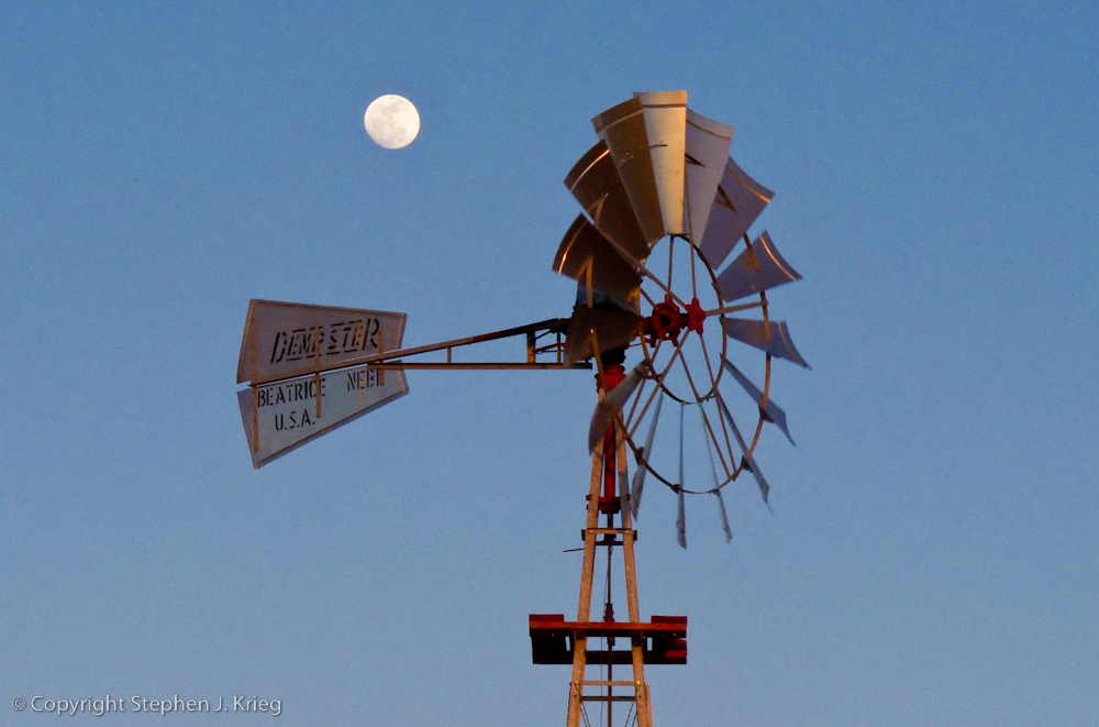
[Photo: Windmill and nearly full moon at sunset, State Route 97]
Leaving Highway 93 north onto State Route 97, I stopped just before the sun dipped behind the western mountains to pair the moon with a windmill pumping water into a water tank for cattle. 


[Photo: Dusk at the Santa Maria River]
Driving east in the dusk on S.R. 96, I crossed the Santa Maria River for the last photo of the day. After driving across the bridge, I parked so I could walk onto the bridge for my intended shot. A heron in silhouette flew south along the river toward wherever its roosting place was for the night.

Finally, it was more desert and canyon driving in the dark, then up over the mountains through the Prescott National Forest via Skull Valley, and back down into Prescott.

So my little drive had turned into a ten hour, 180 mile foray; not unusual for me. Have Camera, Will Travel.

-------------------------

* That must make Flagstaff, 90 miles to the north and about 2,000 feet higher in elevation, Arizona's "Heck of a Lot Higher Than Prescott" City.

(Click on any photo to see a larger version.)

Locations: Yavapai County, central Arizona.