Showing posts with label Utah. Show all posts

Monday, February 20, 2017

Here Comes Spring

Rainbow Trout, February 19.
Until yesterday I had not caught any trout since January 5. The two times I had gone after that were brutal, the cold and wind. Oh, well. If this had been a normal winter here in southeast Utah the lake would have frozen much earlier and the snow much deeper than it has been.

East end of the lake from the dam, February 19.
Back then in early January the lake had opened partially. I had trudged along the part of the dam shoreline that was open, having to keep back from the thin shelf ice. I caught a couple of rainbow trout and then retreated first to my vehicle, then home.

Northeast corner of the lake, Jan. 5.
Over the past few weeks much warmer weather has taken hold. A few light snow storms, but mostly melting of the deep snows that had pointed the local mule deer down to lower elevations where their food would not take so much energy to get to.

Last trout of the winter, Jan. 5.
Yesterday the deer were back. Trout and deer, a good indication of early spring, even at 7,000 feet in late February.

Photo location: San Juan County, southeast Utah.

See more of my photography on my website at www.NaturalMoment.com.

© Copyright 2017 Stephen J. Krieg

Friday, January 20, 2017

Winter at Bryce Canyon National Park, Utah

Bryce Canyon from Sunset Point area, framed by Ponderosa Pine trees in winter.
Talk about your Canyon Country Grand Staircase winter wonderlands. At the top of the list--including elevation wise--has to be Bryce Canyon National Park in southern Utah.

The colors of the Pink Cliffs change throughout the day with the sunlight and shadows, as they do year round. But when there is fresh snow to make each fin and hoodoo (irregularly shaped spires of rock) stand out, it's even more amazing.

Just after sunrise at Bryce Canyon.
 Bryce Canyon is high elevation. The rims in the park range from about 7,900 feet at the Visitor Center to about 9,000 feet at Rainbow Point at the south end of the drive.

Late afternoon sunlight and shadows at Bryce Canyon. The small tilted formation is called the Sinking Ship.
 The Grand Staircase is made up of all the layers of sedimentary rock that were eons ago uplifted from sea level to much higher in the sky. The bottom layers are exposed by the Colorado River at the Inner Gorge of Grand Canyon. The uppermost layers--the Pink Cliffs--are most spectacularly seen here at Bryce and at nearby Cedar Breaks National Monument.

Douglas-Fir trees down among the glowing fins.
As spectacular as the views are from the Rim viewpoints, a hike down into the canyon makes for a whole other experience. The even cooler and moister habitats down among the fins of rock provide a habitat for huge Douglas-Fir (Pseudotsuga menziesii) trees. The sunlight reflects off the orange limestone fins, contrasting with the clear blue high elevation Utah blue skies.

Moonrise just before sunset, from Bryce Point. On the far horizon is the Aquarius Plateau.
 And if you're fortunate to be able to stay until the end of the day at the right time of the month, you can watch the nearly full moon rise at sunset from Bryce Point.

Photo location: Bryce Canyon National Park, southern Utah.

© Copyright 2017 Stephen J. Krieg

Saturday, December 17, 2016

Choppy Lake Sunset Reflection

Sunset reflection and Abajo Mountains.
A cold sunset at the lake, wind whipping the water's surface to whitecaps. I had hopes for a colorful sunset -- the clouds looked to be positioned about right -- but the roiling lake surface would not do its part by providing a mirror surface reflection.

To my surprise, the sunset afterglow colors were so strong that it reflected off the waves, a wrinkled reflection of reds and blues.

Prints and photo products are available on my Fine Art America sales website:
http://stephen-krieg.pixels.com/


© Copyright 2016 Stephen J. Krieg

Thursday, October 13, 2016

Fish and Fall Colors, Abajo Peak

Aspen fall colors and Blue Spruce, Abajo Peak Road.
October, the perfect month. Warm days, chilly nights, fall foliage colors. Here I am still in southeast Utah, enjoying the scenery, clean air, small town atmosphere, wide open spaces.

Rainbow Trout, perfect pan frying size, too.
Not only that but I recently bought my fishing license, after being away from it for decades. Following a tip from a local, I was soon catching my limit of four trout from a local lake. They are in the 9 to 12 inch range, perfect for pan frying.

Aspen at peak fall colors, Abajo Peak area.
 So having once again caught my limit that morning, I drove up Abajo Peak Road to see how the aspen colors had progressed in the past week. Pretty magnificent, at peak colors.

Aspen fall foliage backlit by the midmorning sunlight.
From up near the summit of Abajo Peak, I noted how the uppermost aspen clones, the ones that had turned the earliest, were now done, their leaves dropped. Now it was time for the lower elevation forest groups to show off their peak colors.

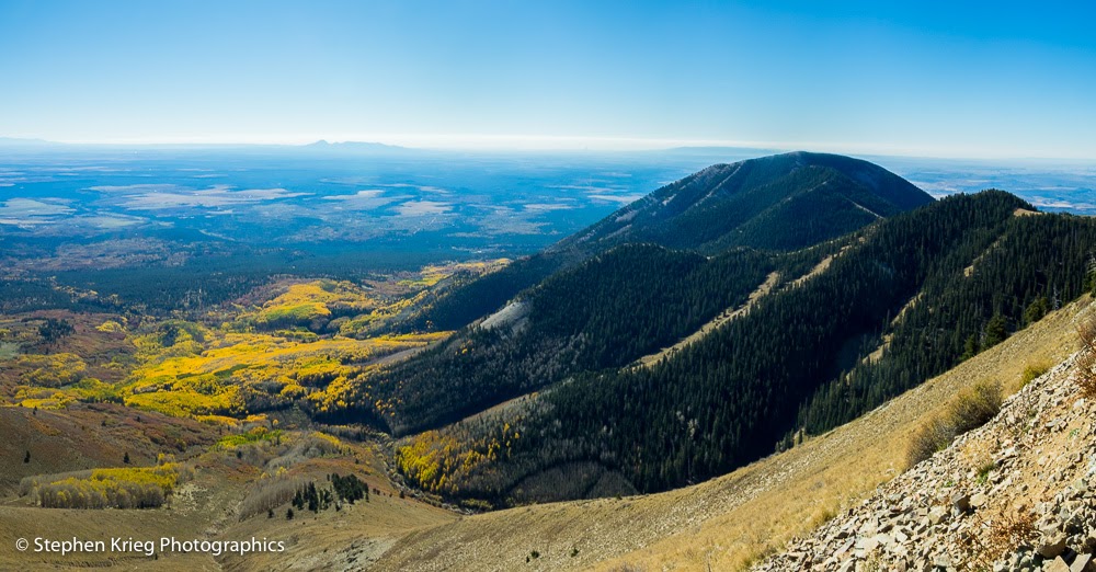
Looking southeast from Abajo Peak.
Photo location: Abajo Mountains, near Monticello, Utah.

Prints and photo products are available on my Fine Art America sales website:
http://stephen-krieg.pixels.com/


© Copyright 2016 Stephen J. Krieg

Wednesday, September 28, 2016

Aspen Colors From Abajo Peak

Fall colors nearing their peak on the lower slopes of the Abajo Mountains, September 25.
The Abajo Mountains are a small mountain range near Monticello and Blanding in southeast Utah.

It's a small mountain range because in geologic terms it's a laccolith -- a spot in the Earth's crust where magma was forced to the surface without breaking the surface. No lava flow. More like a group of skin blisters that hardened in place.

The tallest peak is Abajo Peak, 11,330 feet in elevation at its summit. It's often called Blue Mountain by the locals, or even "the Mountain". It's public land, on the Manti-La Sal National Forest.

The aspen colors have been nearing their peak in the high country of Utah and Colorado. So on a sunny Sunday morning I drove up to the summit of Abajo Peak for a look around from above.

And in this photograph you can see how much elevation affects vegetation, in this case aspen forests. Notice how the aspen stands (clones, actually) at the upper elevations are at their peak fall color, while the lower slopes are still mostly green, just beginning to turn colors.

Photo location: Abajo Peak, Manti-La Sal National Forest, San Juan County, southeast Utah.

© Copyright 2016 Stephen J. Krieg

Thursday, August 4, 2016

Dirty Devil River Bridge Shadow

The Dirty Devil River. from Highway 95.
Down to Hite, down to the Colorado River. Summertime. Hot. Longing for autumn.

© Copyright 2016 Stephen J. Krieg

Friday, June 17, 2016

Hanging Gardens at Natural Bridges

Hanging gardens in the sandstone canyon country of southeast Utah are a true niche environment. Amazing things happen in a small space.


Alcove Columbine in hanging garden, Armstrong Canyon, Natural Bridges National Monument.

They are formed by two things, primarily. One is that sandstone is porous. Water can slowly trickle down between the sand grains, even more so down all the joints in the rock (around here they had been sand dunes about 270 million years ago).

Alcove Columbine, below Kachina Bridge trailhead, Natural Bridges National Monument.

The other is that, on the Colorado Plateau in southern Utah, there are a variety of rock layers. And underneath the sandstone, sooner or later will be a much different layer. One impervious to water. Which means the water will flow sideways instead of down. Gently seeping out the side of an exposed cliff face. And there you have a hanging garden. Specially adapted plants seemingly clinging to a cliff face, or at least at the base of it.

Alcove Columbine closeup.

Since such places tend to be wet and shady, certain plants like it there. One is the Alcove Columbine, a delicately leaved and blossomed plant. Unlike their  much taller and robust cousins growing in the high mountains, these are small blossoms. They don't show off. You have to look for them in the shade of the bright high desert sunlight. 

Another hanging garden denizen is a small shrub, the Birchleaf Buckthorn - Rhamnus betulaefolia. Its almost egg shaped green leaves are distinctive in the park. A wiry stem grows from wherever the water source is, at the base of a cliff or out a crack in a face cliff.

Birchleaf Buckthorn - Rhamnus betulaefolia
In some spots, you might even find ferns. This example is on a terrace above the streambed in Armstrong Canyon. 

Ferns in a hanging garden in Armstrong Canyon at Natural Bridges.
Why ferns in a certain hanging garden but not in others? The same question can be about where Alcove Columbines and Birchleaf Buckthorn grow. Geology and soil type? Seed source? Something to ponder as you pause in the lovely shade of an overhanging cliff in canyon country.  

Photo location: Natural Bridges National Monument, southeast Utah.

© Copyright 2016 Stephen J. Krieg

Thursday, May 26, 2016

Canyonlands May Morning

Sunrise colors over the La Sal Mountains, May 22.
May 22: After two wonderful but too windy nights of camping in the Greater Canyonlands area, it was time to start heading toward home. With all day to do it and only a few hours away, I was rich on time.
 
Sunrise colors over the southern end of the La Sals.

So rich, in fact, that I found myself reluctant to leave. I was feeling relaxed, rejuvenated and serene. It was time to explore a few more nearby places. 

One stop was the Wine Glass, a fantastic study in sandstone erosion. Since the sun was not yet up, the light was soft and graceful.

The Wine Glass. Stone falling apart creates such beautiful sculptures.
But I continued to keep one eye to the east, toward the La Sal Mountains. Because the clouds over those still-snowy peaks looked to have high potential to reflect the rising sun's colors. 

The sunrise flare begins.
Just before the sun was going to clear the northern end of the La Sal range, it lit up the horizon with what I call a sun flare. In this case, a sunrise flare.

"Sunrise flare" closeup and La Sal Mountains.
The flare lasted so long that I had time to make a high resolution panoramic image from overlapping shots, to better portray the entire scene.

Sunrise flare panorama.
The glorious sunrise colors finally done, the clouds continued to tantalize me. Now absent the red-orange-yellow colors, the sunlight poured down in dazzling slanted sunbeams.

Post-sunrise sunbeams over the La Sal Mountains.
A bit further down the road the sunlight was pouring down almost directly from overtop the mountain peaks. Rather heavenly.

Post-sunrise, early morning sunlight shafts, and high desert trees.


Then it was on to the Needles Overlook. Given the past two days of high winds, there was a lot of dust in the air. Plus some moisture from a rain shower. Which meant quite a bit of haze. Which I minimized in post processing in Adobe Lightroom after the shoot.

Needles Overlook: looking south toward the Six Shooter Peaks and the Abajo Mountains.
Enamored with the scene despite the haze, and because the Indian Creek valley floor was so green in this cool and moist springtime weather, I made a really wide panoramic image.

Needles Overlook panorama, looking south.
I walked up around the bend to check out the view to the west, and the north. It was a different scene: little greenery below. But in the foreground, a wonderfully green, gnarled Utah Juniper tree, as if showing off amid the red and brown rockscape.

Needles Overlook, looking north.
Photo location: southeast Utah, near Canyonlands National Park.

© Copyright 2016 Stephen J. Krieg

Sunday, May 22, 2016

May Moonrise, La Sal Mountains from Canyonlands


Moonrise and La Sal Mountains, southeast Utah.
For the May 2016 Full Moon I was in the Canyonlands Basin in southeast Utah. 

The particular spot I was exploring has an unobstructed view of the La Sal mountain range to the east. However, this late in the year the moon rises to the south of the mountains rather than over them like it does during the winter months. So it wouldn't make for killer moonrise over the mountain peaks shots.

The clouds -- the variable of prime importance -- had been questionable for most of the day. At first they were an awful high hazy mess, neither blue sky nor overcast. But as the day wore on the thin high clouds moved on east, and were replaced by a nice mix of cumulus clouds and blue sky. So maybe things would work out, at least as far as sunset colors.

Mount Tukunikivats in the La Sal Range, under hazy afternoon light.
Being in the Canyonlands region, there is always much more to see than just the sky. And since one can't control the weather, one takes what is offered. It's all good here.

The La Sal Mountain Range in afternoon shadow.

The Colorado River south of Moab, Utah under sunbeam overcast skies.


Looking down onto the Kane Creek Anticline at dusk.
As sunset approached, there was even a slight threat of rain to the north. I had been hoping for a last minute breakthrough in the clouds on the western horizon to create some shafts of golden sunlight streaking low across the northern landscape at the last minute. Maybe even an alpenglow event lighting up the snowy peaks of the La Sals in a nice rose hue. It didn't happen, though I was ready. You have to be out there. 

Pre-sunset golden sunbeams to the west.
Toward the east, though, it was partially clear. As the light faded to blue twilight, the Full Moon made its appearance over the gently sloping southern flanks of the La Sals. 

Moonrise over the southern flanks of the La Sals.

 It was a remarkable scene in person. However, any zoomed in shots of the rising moon would seem not at all representative of the total scenery. So I made overlapping shots horizontally to be merged into a high resolution panoramic image.

Two shot panorama of the moonrise and southernmost peaks.
Three shot wide angle panorama: the moon appears smaller, but the overall scene is better represented.
After the last twilight was gone and the brightness of the Full Moon had taken over, it was time to walk back down to camp and enjoy the early night from there.

© Copyright 2016 Stephen J. Krieg

A Perfect May Day at Natural Bridges

Visitors at Kachina Bridge overlook, Natural Bridges National Monument.
Mid May at Natural Bridges National Monument in southeast Utah. For the most part it's been a fairly cool, wet spring. Lovely. The serious canyon hikers have again been out in force, knowing that this is the best time of year (although October is probably even better, because of drier dirt roads into the backcountry). Though spring is the time for the widest variety of wildflowers. 


Cedar Mesa from the Natural Bridges entrance road (Highway 275), looking southwest toward Moss Back Butte and Navajo Mountain.


But the rather wet weather has made things a bit hit and miss for some visitors that come here counting on Utah's trademark deep blue skies.

Today, though, was perfect, I believe. Not hot, not cold. A likely threat of rain showers, but not that high. Spring wildflowers still loving the moisture. Something for everyone.

A visitor walking up the trail from Owachomo Bridge.

At a U.S. National Park unit Visitor Center, the staff get mostly the same questions over and over, depending on the park. At Natural Bridges, they can be boiled down to:

1. Where is the nearest gas station? (35 miles, if you're driving east).

2. Can we buy coffee here? (No.)

3. Is there cell phone service here? (No). 

4. Is there Wi-Fi service here? (No).

5. Where do you all live? (A two minute walk down there to the park's residential housing. Yes, we live here.). 

I'm purposely skipping over "Where are the restrooms?" because most figure it out on their way in. 

Colorado Bladderpod (Physaria rectipes, Mustard family) blooming at Natural Bridges.


So, being out in the middle of nowhere, a small park that was in fact the first national monument in Utah (1908, thank you President Teddy Roosevelt), there are basic visitor needs that need to be quickly sifted through. 

The second level of questions are the basic ones about the park itself. Most concern how much time will it take to see anything? We have answers for that. And much more, especially those that have done their homework and want to see some really cool things, especially those able and interested enough to hike down into the canyons. To those we give special treatment.

A visitor ponders Owachomo Bridge from below.

But not everybody is ready for that. My own first experience with each new national park or other special wild area is that it's in effect a scouting trip. You either never allow enough time to do it justice, even for a first visit, or you've underestimated it and say to yourself: Wow, I'm going to have to come back here. And if you're fortunate, you do. With a lot more time to appreciate it.

Which somehow brings me back to those visitors who don't have much time, or even the physical ability for hiking. It has been designed for both. 

I love hiking down into the park's canyons, beneath the three mighty bridges and the Ancestral Puebloan ruins. I've been here a year and a half, but still feel like I've only dipped my toe into the waters. 

Claretcup hedgehog cactus blooming at Natural Bridges National Monument.


This day I was free of the Visitor Center for a few hours, and the weather was exceptional. Threatening of rain, but that meant gorgeous cumulus clouds in the high desert Utah sky. Sun, shadow, clouds. A bit breezy, but that served to move most of the haze out. Sweet.

I decided to drive the loop road to the natural bridges overlooks, to get new springtime photos to show the visitors before they go out there. 

The first stop was the Sipapu Bridge overlook. Looking down onto the second largest natural bridge in the Americas (and sixth largest in the world). I admired the mid-afternoon light, the glowing bright greenery of the riparian (streamside) tree foliage far below in the rugged canyons of Cedar Mesa Sandstone.

Sipapu Natural Bridge, sixth largest in the world, 500 feet in elevation below the overlook in White Canyon.

Then it was on to Kachina Bridge, the youngest and most massive of the bridges, since it still has the most stone mass left to lose. At the overlook there were several visitors admiring the view. Because it's not just the natural bridge far below. In fact, some can't even pick it out without help. It's because of the stunning scenery of the canyons below. And the cliffs above them. So when we encourage them to "just" go to the overlooks, they will still have an incredible experience.


Kachina Natural Bridge from the overlook, where Armstrong Canyon enters White Canyon.

Finally, the third bridge: Owachomo. The easiest one to hike down to, by far. The longest name, the shortest hike. Probably the oldest one, geologically. Certainly the most photographed one, because of its ease of access, and its wide open southern exposure for midnight starry skies photography. 

Owachomo Natural Bridge (left center) from the overlook, with Moss Back Butte and the Red House Cliffs in the distance.
Owachomo Bridge, from below in Armstrong Canyon.

The final pullout on the park's loop drive road is a panoramic wide toward Elk Ridge, with the Bears Ears Buttes and Maverick Point.

The Bears Ears Buttes, Maverick Point and Elk Ridge from the Bridge View Drive loop road.

So there you go, a brief nine mile driving loop road through Natural Bridges National Monument. Even a brief tour is so rewarding. But don't be surprised if you'll want more.


Even if you live here.


Photo location: Natural Bridges National Monument, southeast Utah.

© Copyright 2016 Stephen J. Krieg