Showing posts with label San Juan County Utah. Show all posts

Thursday, October 13, 2016

Fish and Fall Colors, Abajo Peak

Aspen fall colors and Blue Spruce, Abajo Peak Road.
October, the perfect month. Warm days, chilly nights, fall foliage colors. Here I am still in southeast Utah, enjoying the scenery, clean air, small town atmosphere, wide open spaces.

Rainbow Trout, perfect pan frying size, too.
Not only that but I recently bought my fishing license, after being away from it for decades. Following a tip from a local, I was soon catching my limit of four trout from a local lake. They are in the 9 to 12 inch range, perfect for pan frying.

Aspen at peak fall colors, Abajo Peak area.
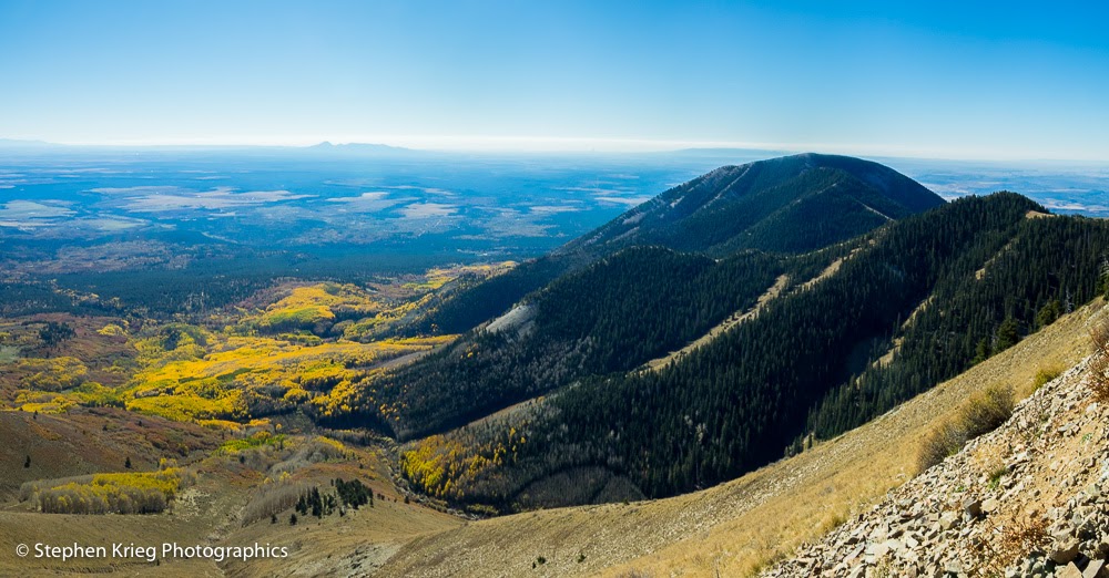
 So having once again caught my limit that morning, I drove up Abajo Peak Road to see how the aspen colors had progressed in the past week. Pretty magnificent, at peak colors.

Aspen fall foliage backlit by the midmorning sunlight.
From up near the summit of Abajo Peak, I noted how the uppermost aspen clones, the ones that had turned the earliest, were now done, their leaves dropped. Now it was time for the lower elevation forest groups to show off their peak colors.

Looking southeast from Abajo Peak.
Photo location: Abajo Mountains, near Monticello, Utah.

Prints and photo products are available on my Fine Art America sales website:
http://stephen-krieg.pixels.com/


© Copyright 2016 Stephen J. Krieg

Monday, September 19, 2016

Harvest Moon Over Cedar Mesa

Rise of the September Harvest Moon over White Mesa in southeast Utah. (Click on image for larger version).
For this month's Full Moon I had set up my tripod at Salvation Knoll on Utah Highway 95, between Blanding and Natural Bridges National Monument.

Salvation Knoll is a high point beneath towering red cliffs along the highway (at 7,110 feet) that affords sweeping views down across Cedar Mesa and even into southwest Colorado and northern Arizona.

The weather was favorable: clear and calm. In fact a bit more than favorable, in that some haze in the air would likely give the rising moon some color. Which it did.

Photo location: San Juan County, southeast Utah.

© Copyright 2016 Stephen J. Krieg
Friday, September 16, 2016

Utah Sunset: Monticello

The town of Monticello in southeast Utah sits at 7,000 feet and at the base of the Abajo Mountains. Small town atmosphere, clean air, and lots of outdoor recreation nearby on millions of acres of public land. Here is a recent sunset series from the edge of town.

© Copyright 2016 Stephen J. Krieg

Friday, July 22, 2016

Comb Ridge Sunset Glow

Comb Ridge and Comb Wash at sunset in July.
Comb Ridge in southeast Utah's San Juan County is a sheer wall whose western escarpment is mostly Entrada Sandstone. It's a monocline, a massive tilt in the Earth's crust at a fault line. It's here that the Monument Upwarp forms the eastern slopes of Cedar Mesa. Steep inclines. Just ask any bicyclist who's climbed the ten miles of adverse grade on Highway 95.

Fortunately you don't have know--or care--anything about geology to appreciate the beauty. The sheer red sandstone cliff faces, the vast vistas with no utility lines whatsoever.

Highway 95's cut through Comb Ridge, from the BLM campground at Comb Wash.
Comb Wash at Utah Highway 95 is a haven for campers in this portion of canyon country in the spring and fall. When daytime temperatures range from cool to warm. But in summer, rarely is a camper here. It's hot, even though the huge Cottonwood trees provide a lot of shade. Besides, now the high country mountain roads are finally dry (except when it rains), so why not go up there into the coolness?

At sunset time, though, when the low angle of the sunlight warms up the cliffs, it doesn't matter what time of year it is. It's time to photograph.

© Copyright 2016 Stephen J. Krieg


Lightning Storm from Salvation Knoll

Monsoon thunderstorm at dusk, Cedar Mesa, southeast Utah.
I was driving Utah Route 95 west from Blanding, watching the evening thunderheads pouring down rain here and there in the distance. That evening light: brilliant and seductive.

Climbing up the highway onto Cedar Mesa, there are clear views for many miles to the south and southeast, toward Sleeping Ute Mountain in Colorado, even. Great for landscape photography with lots and lots of sky.

Adding to the interest were flashes of lightning inside of two storm cells. The one nearer to me was of more interest in that I might be able to capture a bolt or two in the scenery.

At Salvation Knoll I stopped for a second try. Mounting the camera on tripod, I set it for the longest exposure, about 4 seconds at f/22 at ISO 200. Then I shot whenever a flash appeared, hoping it would be long enough for me to get lucky.

I enjoy this image because the clouds, with their rain curtains, look quite dreamy against the darker blue of the distant storms.

Photo location: Salvation Knoll on Cedar Mesa, San Juan County, southeast Utah.

© Copyright 2016 Stephen J. Krieg

Sunday, May 22, 2016

A Perfect May Day at Natural Bridges

Visitors at Kachina Bridge overlook, Natural Bridges National Monument.
Mid May at Natural Bridges National Monument in southeast Utah. For the most part it's been a fairly cool, wet spring. Lovely. The serious canyon hikers have again been out in force, knowing that this is the best time of year (although October is probably even better, because of drier dirt roads into the backcountry). Though spring is the time for the widest variety of wildflowers. 


Cedar Mesa from the Natural Bridges entrance road (Highway 275), looking southwest toward Moss Back Butte and Navajo Mountain.


But the rather wet weather has made things a bit hit and miss for some visitors that come here counting on Utah's trademark deep blue skies.

Today, though, was perfect, I believe. Not hot, not cold. A likely threat of rain showers, but not that high. Spring wildflowers still loving the moisture. Something for everyone.

A visitor walking up the trail from Owachomo Bridge.

At a U.S. National Park unit Visitor Center, the staff get mostly the same questions over and over, depending on the park. At Natural Bridges, they can be boiled down to:

1. Where is the nearest gas station? (35 miles, if you're driving east).

2. Can we buy coffee here? (No.)

3. Is there cell phone service here? (No). 

4. Is there Wi-Fi service here? (No).

5. Where do you all live? (A two minute walk down there to the park's residential housing. Yes, we live here.). 

I'm purposely skipping over "Where are the restrooms?" because most figure it out on their way in. 

Colorado Bladderpod (Physaria rectipes, Mustard family) blooming at Natural Bridges.


So, being out in the middle of nowhere, a small park that was in fact the first national monument in Utah (1908, thank you President Teddy Roosevelt), there are basic visitor needs that need to be quickly sifted through. 

The second level of questions are the basic ones about the park itself. Most concern how much time will it take to see anything? We have answers for that. And much more, especially those that have done their homework and want to see some really cool things, especially those able and interested enough to hike down into the canyons. To those we give special treatment.

A visitor ponders Owachomo Bridge from below.

But not everybody is ready for that. My own first experience with each new national park or other special wild area is that it's in effect a scouting trip. You either never allow enough time to do it justice, even for a first visit, or you've underestimated it and say to yourself: Wow, I'm going to have to come back here. And if you're fortunate, you do. With a lot more time to appreciate it.

Which somehow brings me back to those visitors who don't have much time, or even the physical ability for hiking. It has been designed for both. 

I love hiking down into the park's canyons, beneath the three mighty bridges and the Ancestral Puebloan ruins. I've been here a year and a half, but still feel like I've only dipped my toe into the waters. 

Claretcup hedgehog cactus blooming at Natural Bridges National Monument.


This day I was free of the Visitor Center for a few hours, and the weather was exceptional. Threatening of rain, but that meant gorgeous cumulus clouds in the high desert Utah sky. Sun, shadow, clouds. A bit breezy, but that served to move most of the haze out. Sweet.

I decided to drive the loop road to the natural bridges overlooks, to get new springtime photos to show the visitors before they go out there. 

The first stop was the Sipapu Bridge overlook. Looking down onto the second largest natural bridge in the Americas (and sixth largest in the world). I admired the mid-afternoon light, the glowing bright greenery of the riparian (streamside) tree foliage far below in the rugged canyons of Cedar Mesa Sandstone.

Sipapu Natural Bridge, sixth largest in the world, 500 feet in elevation below the overlook in White Canyon.

Then it was on to Kachina Bridge, the youngest and most massive of the bridges, since it still has the most stone mass left to lose. At the overlook there were several visitors admiring the view. Because it's not just the natural bridge far below. In fact, some can't even pick it out without help. It's because of the stunning scenery of the canyons below. And the cliffs above them. So when we encourage them to "just" go to the overlooks, they will still have an incredible experience.


Kachina Natural Bridge from the overlook, where Armstrong Canyon enters White Canyon.

Finally, the third bridge: Owachomo. The easiest one to hike down to, by far. The longest name, the shortest hike. Probably the oldest one, geologically. Certainly the most photographed one, because of its ease of access, and its wide open southern exposure for midnight starry skies photography. 

Owachomo Natural Bridge (left center) from the overlook, with Moss Back Butte and the Red House Cliffs in the distance.
Owachomo Bridge, from below in Armstrong Canyon.

The final pullout on the park's loop drive road is a panoramic wide toward Elk Ridge, with the Bears Ears Buttes and Maverick Point.

The Bears Ears Buttes, Maverick Point and Elk Ridge from the Bridge View Drive loop road.

So there you go, a brief nine mile driving loop road through Natural Bridges National Monument. Even a brief tour is so rewarding. But don't be surprised if you'll want more.


Even if you live here.


Photo location: Natural Bridges National Monument, southeast Utah.

© Copyright 2016 Stephen J. Krieg

Friday, January 16, 2015

Snowy Peaks, Red Rock Canyons

[Comb Ridge, San Juan County, Utah] 
A local friend calls Highway 95 west from Blanding, Utah "the road to the good stuff". And she should know, having combed this region for about 30 years. 

So I was again driving Hwy. 95 west, savoring the sights as usual. Up and through the massive cut in the red sandstone at the crest of Comb Ridge. Then down the west side, crossing Comb Wash. And up onto Cedar Mesa, the million-acre wild land with all the rugged canyons cut into its sides. Where everybody comes to hike down in to see the ancient Anasazi / Ancestral Puebloan cliff dwelling ruins that were last inhabited about 700 years ago. Great stuff. Part of my friend's "good stuff". 

Pulling over at a favorite viewpoint where I could see north from the lip of Cedar Mesa, I enjoyed the view toward Comb Ridge and the distant Abajo, or Blue, Mountains west of Blanding and Monticello. 
a
[Abajo Mountains through the clouds, from Cedar Mesa] 
This sums up a lot of what I appreciate about San Juan County: red rock canyons and snow capped mountains. Geology, archaeology, ecological diversity, and plenty of it.

© 2015 Stephen J. Krieg

Sunday, January 11, 2015

Snowscapes in Slickrock Country

[Butler Wash area in snow, San Juan County.] 
A lovely mid winter storm in southeast Utah. Canyon Country, Four Corners Country. Perfect snow, and I was in the mood for roaming outdoors again.

From Blanding west on Highway 95. Such a wonderfully lonesome road. Unless you consider the seeming suicidal deer, which can instantly decide that somehow the other side of the road must be the safer side. 

On this morning, though, the snowstorm had the deer bedded down in the trees, in the draws, out of harm's way. So the highway was mine.

I had plenty of time. Thus a diversion: stop and hike the short (half mile) trail to the viewpoint of Butler Wash Ruins. 
[Snowy bench, Butler Wash] 
"Ruins," as in the remains of ancient pueblos, tucked under a massive sandstone cliff. I had visited there before, even hiked down into the Wash and up to the ruins themselves. But today I would content myself with confining myself to the trail to the overlook. It should be beautiful, and slippery enough without being even more adventuresome.
[700-year-old (or so) pueblo ruins.] 
I was the first one through the virgin snow that day. It was still so overcast, and the snow so white, that it was hard to discern the lay of the trail. So I stumbled and slid a bit, taking care not to fall. My goal was to make it to the viewpoint without putting my traction aids on my boots, just to see whether I could. 

I decided I couldn't. Or at least shouldn't. The experiment was complete, so I stretched them over my soles and enjoyed a much more confident trek.
[Pull-on traction devices, huge difference.]
At the ruins overlook, I made my photos and video of the wide mouthed alcoves in the cliff across the way. Then I started back toward the trailhead. The view to the south caught my eye, so I strayed off trail across the sandstone slickrock. The tiny intermittent stream was flowing down through the snow. Beautiful, sensual patterns in the perfect snow.
[Small pools in the slick rock.] 
[Sideways slickrock stream.]  
 
[Snowflakes on ice veneer, on pool.] 

[Prickly pear cactus in the snow.] 

Photo location: San Juan County, southeast Utah.

Prints and photo products are available on my Fine Art America sales website:
http://stephen-krieg.pixels.com/


© 2015 Stephen J. Krieg 

Tuesday, January 6, 2015

The Clouds Part

Highway 95, west of Natural Bridges, Utah.
Utah Highway 95, down along White Canyon. No cell service, no problem. Because I'd rather be using my camera, anyway.

An inversion still had the cloud cover down low. But not all the way to the river. Sweet. I could play both sides of it just by driving along.

Fresh snow, fog, blue skies, red rock cliffs. A highway so lonesome you only see a few cars in an hour.

Photo location: San Juan County, southeast Utah.


Saturday, December 13, 2014

December Weather Finally Arrives in Canyon Country

[Outside the snowy Visitor Center, Natural Bridges National Monument, Utah.]
I was up this morning well before dawn, as usual. Soon after I could hear the rain falling on the roof: the promised storm front had moved inland from California all the way to southeast Utah. 

But soon after...no sound. It was getting light, so I looked outside and saw snow falling. The rain had become the white stuff that quickly. Falling straight down, no wind. A wet, heavy, beautiful snowfall.

Russ and I opened the Visitor Center. Old Glory raised on the flagpole, cash registers open for business, visitor statistics logged on the clipboards. Lights turned on inside. Sidewalk shoveled. Soothing instrumental music playing. 


Nobody came. Not right away. That's all right, we're out in the middle of nowhere and it takes some time to get here. Meanwhile our erstwhile maintenance crew was running the snowplow truck, clearing the road in from Highway 95. 

Eventually the first visitor came. Then a couple more. Such soft glowing snow light outside, coming in through our floor to ceiling windows. Wet snow sticking on every piece of vegetation outside. 

I walked down to the house to eat lunch. The clouds were starting to clear. I had to get out there, had to do a rove, even though there were only two of us manning the Visitor Center. After all, we weren't exactly being swamped by visitors. Though the few that came enjoyed it: welcoming, peaceful, no lines of tourists. 

[Canyonlands Natural History Association Book Store, Natural Bridges Visitor Center, snowy day].
 So out the loop drive, Bridge View Drive officially, I drove. Stopped to take photos in the bright light, the reflections on the wet slickrock sandstone, on the surfaces of the water pockets. 

On the trail down to Kachina Bridge I met up with two young ladies that I'd talked to in the Visitor Center. "Did you come to check on us?" Well, yes. Maybe. I knew you'd be fine, the road is fine and it's above freezing so there will be no ice on the trails. Until morning. I came to check on the Park. On this fantastic place, the only place in the world with three mighty stone bridges within a few miles of each other. With fresh snow on the mesa rim. That's what I came to check on. 

[Walkway to Sipapu Bridge viewpoint, some blue sky already].
Meanwhile, back at the Visitor Center Russ and I wrapped up the day. I tallied up the sales. The book store proceeds go into the Park programs, not into some corporation's balance sheet. I gently point that out to visitors whenever I can, because they like knowing that. Give back to the park while buying something you like. It's synergy.

But the day was not quite done. Still on the menu: sunset. 

I drove out to the big curve I've dubbed Sunset Curve. Why? Because it's a big curve in the road. Ok, ok, but because it has a nice turnout spot which faces west for the sunset. Awesome view, no power lines, no nothing except clean air, high desert mesa, buttes and sky. 

As sunset colors go, it was muted. Which only served to not distract me from the foreground, the fresh snow on the sandstone boulders, the high desert mesa. I loved the soft light, I walked around with my camera and tripod all around.

[Snowy sandstone boulders at sunset].
If it gets much better than this, I don't want to know about it. I'm not sure I could take it. Though I'd try.

---------

Photo location: Natural Bridges National Monument, San Juan County, southeast Utah. 

Click on each image for a much larger version.


Prints and photo products are available on my Fine Art America sales website:
http://stephen-krieg.pixels.com/


© 2014 Stephen J. Krieg

Monday, December 8, 2014

Moon Leaving, Sun Arriving, Natural Bridges

Moonset and Earth's Shadow at Dawn.
I got skunked this month as far as my monthly moonrise shots of the Full Moon. That's why I try to be ready each month, because you only get twelve a year, and some of them will be snuffed out by unfavorable weather. Or you need to be doing something else. That sort of thing.

The evening of the December Full Moon had too many clouds on the eastern horizon where I was in southeast Utah's high desert canyon country. By the time the moon appeared through the thin clouds it was hazy, wan. Blah.

My backup plan for moon landscapes is the morning after Full Moon: moonset. Most photographers overlook that time, when being out at dawn allows you to position the setting moon in a landscape facing west instead of east. 

I was at Natural Bridges National Monument. Being December, I had the Bridge View loop drive to myself that early in the day. Winding along the rim of White Canyon, I stopped for a look down at Sipapu Bridge. The stone bridge itself was too dark for a good photo that early, but I noticed the small potholes in the sandstone bedrock that had water still in them from the last rain. I made a composition with one reflecting the moon. 
Moon reflection in sandstone pothole at dawn.


Then further along the loop drive, I liked how the dawn colors were shaping up in advance of sunrise. The Earth's shadow and the blue to pink gradations of the Venus Belt made for another moonset shot. 

Finally I was at Owachomo Bridge, the oldest of the three stream carved bridges in the park. I was hoping to find some angle to get the bridge and the moon together in a shot. Owachomo is the best candidate for that, because it's much more out in the open than the other two bridges, Sipapu and Kachina. 

Moon setting over Red House Cliffs.
 But I couldn't find the angle necessary. So I enjoyed being down underneath the bridge once again ("Owachomo" is Navajo for "under the horse's belly"). If it was a horse's belly, it was one long, skinny horse. Majestic in its own way. A slender bridge compared to the other two, this one is the oldest, the most eroded and so the thinnest. It will fall the soonest. Whenever that might be.

But not this morning. I continued down slope from the bridge, to the stone lip along the creek still slowly carving Armstrong Canyon. 

From down there I could not yet see the sunrise itself. But it was lighting up the south side of Owachomo's sandstone span. With clear blue sky behind. Nice, very nice. 
Owachomo Bridge at Sunrise, December.
Photo location: Natural Bridges National Monument, San Juan County, southeast Utah. Click on any photo to enjoy a much larger version.

Prints and photo products are available on my Fine Art America sales website:
http://stephen-krieg.pixels.com/


© 2014 Stephen J. Kriewg

Saturday, November 22, 2014

Cedar Mesa Sunset Skies

[Photo: Cedar Mesa sunset panorama, southeast Utah. Click on image for larger version].
The clouds built throughout the day. Not ominously, but maybe more toward the slight chance of mixed rain and snow forecast for the night. 

I've become a weather forecast pessimist. In that the precipitation, be it rain or snow, won't materialize where I am. The weather service seems to over-forecast, to cover their butts, so we dear citizens aren't caught unaware of a bad storm. Ok, so we're prepared, usually for nothing.

As evening approached I, as usual, gauged the chances for a fiery sunset. The clouds have to be in the right position. All afternoon I'd written off the prospects as being too overcast. But at 4:45 I saw a clear slot on the western horizon just north of Moss Back Butte, where the sun would set. Hmm. If those clouds stay like that, it could really light up.

My stomach got the better of me. Should I go to one of my favorite sunset spots and wait, wait, hungrily? I did not. Then while I was cooking a pasta meal, furtively glancing out the picture window, the conditions fell right into place. 

Turn off the stove and dash out there. Fortunately I have a backup sunset spot nearby, a minute's walk away. I used it. Made several overlapping images, then -- after supper, of course -- merged them into a huge high resolution panorama master file. 

I should have been at my best sunset spot, though. With a bag of chips to tide me over. Next time, next time.
[Photo: Sunset afterglow, Natural Bridges, Utah].
---------

Photo location: Natural Bridges National Monument, San Juan County, Utah. Olympus E-PL5, developed in Adobe Photoshop and Lightroom 5.